
J-AASJ 2023-1 vol.5
日本天文考古学会の学会誌5号
2024年3月1日発刊
A4版オールカラー112ページ
一冊、送料・税込みで3000円
本会誌を入手したい方は、お問い合わせのページからお申し込みください。
表紙写真:奈良県山添村のあたごさん、撮影 山村善太郎

--------目次-----------
●巻頭言 上田晴彦
論文
●神谷太刀宮神社の岩石遺構と天体との関係 平津豊
●ストーンヘンジにおける夏至と冬至のシミュレーション 樋口元康
●松山市・白石の鼻巨石群の天文観測所の配置と利用について Joachim Pieter JONCKHEERE
●上原(わっぱら)遺跡の環状列石と天体観測 柳原輝明
●方向統計学を用いた湯出野遺跡の墳墓群の方位についての考察 上田晴彦
●縄文時代の岩石運搬技術 平津豊
●平原遺跡出土の方格規矩四神鏡から解ける魏志倭人伝の方位問題 桜田和之
研究ノート
●天文シミュレーションソフト及び岩石遺構モデル化の検証 篠澤邦彦
●神社の参道方位と日の出・日の入方位に関する予察 北川達彦
活動報告
●明日香村天宮(両槻宮)推定地の調査報告書
テクニカルワンポイント
●岩石の見方 正野英憲・
学会ニュース
●第3回研究発表会報告
●白石の鼻巨石群見学ツアー報告
学会誌 要約紹介 通巻5 2023年1巻1号
VOL5-1◆(論文)神谷太刀宮神社の岩石遺構と天体との関係 平津豊
Relationship between rock remains and celestial bodies at Kamitani-Tachinomiya shrine.

京都府京丹後市の神谷太刀宮神社に存在する岩石遺構を利用して天体観測を行っていたのではないかという仮説を検証した結果、東壁は兜山の右肩から昇る夏至の朝日の方向を向いていた。古代人は、夏至の到来を知って1年の基準とすると同時に人喰岩を遥拝していたと推測した。
Results of verifying the hypothesis that astronomical observations were conducted using the rock remains at Kamitani- Tachinomiya Shrine in Kyotango City, suggest that the east wall faced the direction of the summer solstice sunrise, rising from the right shoulder of Mount Kabuto. These suggests that ancient people likely used this rock to determine the arrival of the summer solstice and, at the same time, engaged in remote worship of Hitokuiiwa.
VOL5-2◆(論文)ストーンヘンジにおける夏至と冬至のシミュレーション 樋口元康
Simulation of Summer and Winter Solstices at Stonehenge.

ストーンヘンジではサーセンサークルの中心から、北東方向にヒールストーンがあり、その背後から夏至の日の出が昇る。天文シミュレーションソフト「ステラナビゲータ」を用いて、ストーンヘンジの建造段階ごとに日の出を再現したところ、夏至の日の出の方位は、紀元前2500年から現在までに約1.0度移動していた。ヒールストーンは高い精度で設置されていることから、建造者は夏至とは逆の冬至の日の入りも観測していたと考え、未知の観測点をシミュレーションで探索した。
When we look at the summer solstice sunrise from the center of the sarsen circle of Stonehenge, we see it in the direction of the Heel Stone. I used an astronomical simulation software called “StellaNavigator” to reproduce the results for each construction stage of Stonehenge, and found that the azimuth of the summer solstice sunrise had shifted by about 1.0 degree from 2500 BC to the present. Since the Heel Stone was placed with high precision, I thought that the builders also observed the winter solstice sunset, and I started to search for unknown observation points.
VOL5-3◆(論文)松山市・白石の鼻巨石群の天文観測所の配置と利用について Joachim Pieter JONCKHEERE
Notes on the Layout and Usage of the Shira-ishi-no-hana Megalithic Astronomical Site.

白石の鼻の巨石群と天体との関係をより深い理解のため探索的研究を行った。先行研究によって確認された天文観測装置と位置は論理的且つ数理的に配置されており、太陽と月軌道の特徴を初めに、様々な天文的現象を観測できることが見受けられる。カサネ石を含む白石の鼻の天文観測所を成す岩群は自然物ではなく、縄文時代、あるいは海水面がもっと低い時代に造られ、まだ十分に調査されていない文明の痕跡であると考える理由が数多く残されている。
An exploratory study of the megalithic astronomical observatory at Shira-ishi-no-hana, Matsuyama-shi, shows that the site has a logical, mathematical layout and can be used for accurate observations of solar and lunar cycles, among others. Several characteristics of previously identified points of interest support an interpretation that these megalithic objects are not a natural phenomenon but human artifacts. The site may have been built during the Jomon period or at a time when the sea level was lower than it is today.
VOL5-4◆(論文) 上原(わっぱら)遺跡の環状列石と天体観測 柳原輝明
Stone circles and stargazing at the Wappara ruins.

長野県大町市にある上原(わっぱら)遺跡は、縄文時代前期中葉(5000年前)の集落跡である。そこに立石で構成された大小二つの環状列石がある。祭祀遺跡とも天体観測施設とも言われているが定かではない。本稿では、これら二つの環状列石が天体観測施設であるのかどうか、また環状の立石がどのような役割を持っているのか、さらには、何故大小二つの環状列石が存在しているかについて明らかにした。
The Uehara ruins in Ohmachi City, Nagano Prefecture are ruins of a village in the middle of the early Jomon period (5,000 years ago). There are two stone circles, one large and one small, made up of stone pillars. It is said to be a ritual site and an astronomical observation facility, but it is not certain. In this paper, we will clarify whether these two stone circles are astronomical observation facilities, what stone pillar they play, and why there are two large and small stone circles.
VOL5-5◆(論文) 方向統計学を用いた湯出野遺跡の墳墓群の方位についての考察 上田晴彦
A Study on the Orientation of Ancient Tomb Group at Yudeno site by Using Directional Statistics.

縄文人が方位および二至二分に関する知識を、どの程度まで持っていたのかは、現在でも完全に解明されたわけではない。その一端を探るため、本論文では湯出野遺跡の103基の土壙に着目した。仮にこれらの土壙を造る際に何らかの意図(例えば亡くなった日時の太陽の日の出・日の入りの方向に合わせて、土壙の軸が決定されるなど)があったなら、これらの土壙の軸性角度が一様分布からずれていることが見いだせるはずである。ほぼ円形であるため、軸性角度を明確に決められない11基を除いた92基の土壙を用い、それらの軸性角度が一様分布からずれているかを、方向統計学の手法であるレイリー検定を用いて調べた。その結果、土壙群が一様分布からずれていることを肯定する結果を得ることが出来なかった。そのため湯出野遺跡の土壙群からは、縄文人の方位および二至二分に関する認識をうかがい知ることが出来ない、との結論に達した。
It is not clear whether the Jomon people had knowledge of azimuth、 solstices and equinoxes or not. In this paper、 we focus on 103 ancient tombs at Yudeno site. If there was any intention in building these ancient tombs (for example、 the axis of the tomb is determined in accordance with the direction of sunrise or sunset on the date of death)、 it should be found that the axial angle of these tombs deviate from the uniform distribution. Using 92 tombs except for 11 circular-shape tombs whose axial angles could not be clearly determined、 the deviation of axial angles from the uniform distribution is examined using Rayleigh test which is a technique of the direction statistics. As the result、 it is not obtained the positive result that the tomb group deviated from the uniform distribution. We therefore conclude that the tomb group at the Yudeno site could not prove the recognition of Jomon people about the azimuth、 solstices and equinoxes.
VOL5-6◆(論文)縄文時代の岩石運搬技術 平津豊
Rock transport technology of the Jomon period.

縄文時代には巨岩を運搬し、組み上げる技術は無かったと言われているが、その巨岩を組み上げる技術は具体的に何を指すのかを明確にし、それが縄文時代に存在できない程、高度な技術であるのかを検討した。その結果、巨岩を人力で組み上げるには、テコ、ソリ、コロ、ソリ道、潤滑剤、傾斜路の技術があれば可能である。これらは経験から編み出される工夫の技術であり、縄文時代に存在しなかったと推測する積極的な理由は見当たらない。
It is said that during the Jomon period there was no technology for transporting and assembling huge rocks. This paper clarified what the specific technology is for assembling huge rocks, and considered whether this technology was so advanced that it could not have existed in the Jomon period. As a result, assembling huge rocks by hand is possible if you have leverage technology, sled technology, roller technology, sled road technology, lubricant technology, and slope way technology. These technologies are "devices" created from experience. There is no reason to suppose that these techniques did not exist during the Jomon period.
VOL5-7◆(論文)平原遺跡出土の方格規矩四神鏡から解ける魏志倭人伝の方位問題 桜田和之
Solving the Orientation Issue of Gishiwajinden through the Hōkakukiku Shishinkyo Mirrors Unearthed at the Hirabaru Site.

古代伊都国の遺跡である平原遺跡から出土した方格規矩四神鏡には、十二支の「子」が北を向いているもの(A型)と、西を向いているもの(B型)がある。一般的な方位基準としてはA型が用いられるのであるが、伊都国は独自のB型を考案し、それを伊都国の十二支方位とした。共立されて倭国大王となった卑弥呼は、伊都国のB型と同じものを倭国でも採用した。卑弥呼がそれを採用した理由は、「子」を背面にして「午」を前面とする東向きの子午ラインを都城の中軸線とし、その東端(午の方位にあるから「馬台」という)に離卦(☲)である陰神を祀り、西端に坎卦(☵)である陽神を祀るためであった。その子午ラインは、柳宿の距星が真東に見えるときに、北に3度~9度振れる方向となるように設定されていた。畿内纒向で見つかっている王宮跡の遺構中軸線は、卑弥呼が採用した東向きの子午ラインを踏襲しており、第一期中軸線として真東から北に6.10度振れる錯玄武ライン、第二期中軸線として4.17度振れる錯玄武ラインが採用されている。第二期中軸線の東端である馬台に篠畑神社が位置していること、垂仁天皇紀に倭姫命が天照大神を奉斎して宇陀の篠畑に行ったという記事があることから、纒向王宮は垂仁天皇の纒向珠城宮であることが判明した。秦楽寺境内の三教嶋は、崇神紀に記されている笠縫邑の天照大神鎮座地である。魏の正始年間に来倭した魏使らは、当時の倭国で用いられていたB型十二支方位基準に従って旅程を記録して本国に報告したに違いなく、魏の魚豢が『魏略』を私撰するに際して、実情を知らない魚豢はA型に基づいて旅程記録の方位を東西南北方位に変換したのである。その結果、魏志倭人伝に記録されている方位は実際の方位を時計回りに90度回転した方位となっている。よってそこに記録されている方位を反時計回りに90度回転することで、魏使たちが歩んだ当時の倭国の東西南北方位を復元することができる。正しく復元された魏志倭人伝の旅程記録からは、邪馬台国は畿内にあったとして問題ない。
The hōkakukiku shishinkyo mirrors, unearthed from the Hirabaru ruins—an ancient site of the Ito state—are categorized into two types: Type A, with the 'Zi' (Rat) of the Chinese zodiac facing north, and Type B, where it faces west. While Type A serves as the general directional reference, the Ito state introduced its distinctive Type B, establishing the twelve zodiac directions of Ito. It is believed that Queen Himiko, who assumed the throne as the ruler of the Kingdom of Wa, also embraced the same twelve zodiac directions as those of the Ito state in Wa. Her reason for adoption was to institute an east-facing Zi-Wu Line, positioning 'Zi' at the rear and 'Wu' at the forefront. At the eastern end of this line (referred to as "Matai"), the Yin deity, represented by the trigram Li (☲), is enshrined, while at the western end, the Yang deity, represented by the trigram Kan (☵), is enshrined. This Zi-Wu Line was designed to be oriented 3 to 9 degrees north when the distant star of the 'Willow' constellation is visible in the true east. The Central Axes of the Makimuku Palace ruins discovered in Kinai Makimuku are based on the eastward Zi-Wu Lines adopted by Queen Himiko. It employs the Incorrect Genbu Line, deviating 6.10 degrees north from true east, as the first-phase Central Axis, and another Incorrect Genbu Line, deviating 4.17 degrees, as the second-phase Central Axis. The presence of Sasahata Shrine at the eastern end (Matai) of the second-phase Central Axis, along with the mention in the Emperor Suinin Chronicle of Princess Yamatohime-no-mikoto visiting Sasahata in Uda to offer prayers to the deity Amaterasu, suggests that the Makimuku Palace ruins are likely the Makimuku Tamaki Palace of Emperor Suinin. The Sangō Island in the precincts of Jinrakuji Temple is identified as the site where the deity Amaterasu was enshrined in the village of Kasanui, as recorded in the Sujinki.
VOL5-8◆(研究ノート) 天文シミュレーションソフト及び岩石遺構モデル化の検証 篠澤邦彦
Verification of astronomical simulation software and rock remains modeling.

天文考古学の発展には、対象となる巨石遺構が古代の天体観測機能を持っていたことを科学的、客観的に検証していく手法がますます求められるようになると考える。現在、学会員が多く利用している天文シミュレーションソフト及び学会員が提案した岩石遺構の分類によるモデル化を筆者自身が研究対象としている白石の鼻巨石群で適用し、その手法が天文考古学の客観的な検証において有効なのかを検証した。検証の結果、その有効性を確認できた。
I believe that the development of astronomical archeology will increasingly require methods to scientifically and objectively verify whether the megalithic remains in question had an ancient astronomical observation function. Currently, the astronomical simulation software that is widely used by members of the society and the patterning and modeling based on the classification of rock remains proposed by the members of the society are applied to the megalithic group of Shiroishi, which is the subject of my own research. We verified whether it is effective in objective verification. As a result of verification, its effectiveness was confirmed.
VOL5-9◆(研究ノート)神社の参道方位と日の出・日の入方位に関する予察 北川達彦
Preliminary Note on the Direction of the Approach Path to the Shinto Shrine and the Direction of Sunrise/Sunset.
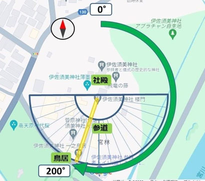
縄文時代、日本に農耕文化が伝わった。農耕社会では、作物を育てるために季節変化の把握が欠かせない。特に季節の折り返し点である冬至や夏至の時期を知ることは重要である。
そのころ、日本各地に神が降臨する祭祀の場(磐座)があった。後に、その磐座付近に神社が建てられていることが少なくない。遺跡としての神社の参道と太陽運行の季節変化との関係を検証するために、日本各地の神社の参道方位の予備的調査を地図上で試みた。その結果、いくつかの神社で、夏至や冬至の日の出・日の入り方位に参道が敷設されていることがわかった。本稿では、神社の参道が太陽運行の季節変化を把握する役割を担っていた可能性について報告する。
During the Jomon period, agriculture was introduced to Japan. In an agricultural society, it is essential to understand seasonal changes in order to grow crops. It is especially important to know the time of the winter solstice and summer solstice, the turning points of the seasons.
At that time, there were places of ritual (Iwakura) where gods descended throughout Japan. Later, not a few shrines were built near those Iwakura. In order to verify the relationship between the approach path to shrines and seasonal changes in solar movement, we attempted a preliminary map-based survey of the approach directions of shrines throughout Japan. As a result, we found that some shrines have approach paths laid out in the sunrise and sunset directions of the summer and winter solstices. This paper reports on the possibility that shrine approaches may have played a role in understanding the seasonal changes in solar movement.