
J-AASJ 2022-1 vol.4

日本天文考古学会の学会誌4号
2023年3月1日発刊
A4版オールカラー84ページ
一冊、送料・税込みで3000円
本会誌を入手したい方は、お問い合わせのページからお申し込みください。
表紙写真:奈良県山添村の鍋倉渓、撮影 山村善太郎

--------目次-----------
●巻頭言 上田晴彦
論文
●三内丸山遺跡大型掘立柱建物についての一考察 柳原輝明
Sandai Maruyama Ruins Study on Large dug-out pillar building. (Teruaki YANAGIHARA)
●岩石遺構と太陽の関係の分類 平津豊
Classification of relationship between rock remains and the sun. (Yutaka HIRATSU)
●玄武ラインの発見 桜田和之
Discovery of Genbu Lines. (Kazuyuki SAKURADA)
●キトラ天文図の謎を解く 桜田和之
Solving the mystery of Kitora celestial chart. (Kazuyuki SAKURADA)
●バルカン半島初期金属器時代の天文関連装飾について:ブチェドール文化を中心に 後藤明
Astronomical decorations of the early Metal Age in the Balkan peninsula.:Focusing on Vućedol Culture. (Akira GOTO)
研究ノート
●巨石ネットワークの幾何学的アプローチから考案されたコンパスとしての台式土偶 小林由来
A portable clay figure as a compass devised from the geometric approach of megalithic networks. (Yoshiki KOBAYASHI)
活動報告
●天文考古学を利用した地域活性化への取組みと後進への助言 篠澤邦彦
テクニカルワンポイント
●天文シミュレーション 平津豊
学会ニュース
●第2回 研究発表会報告
●明日香村見学ツアー報告
学会誌 要約紹介 通巻4 2022年1巻1号
VOL4-1◆(論文) 三内丸山遺跡大型掘立柱建物についての一考察 柳原輝明
Sandai Maruyama Ruins Study on Large dug-out pillar building Teruaki YANAGIHARA

三内丸山遺跡の大型掘立柱建物は縄文時代を代表する木造の高層建物であるが、用途は明解に示されていない。再現された姿は6本の柱と何層かの床が設けられただけの用途不明の構造物となっている。名称も「大型掘立柱建物」という残念な呼ばれ方である。用途の特定が出来ればおのずとその呼び名も姿も変わってくるものと考える。本稿では、構造物の建つ場所や向き、高さ等からその用途を類推する。
The large dug-out pillar building at the Sannai-Maruyama ruins is a wooden high-rise building representative of the Jomon period, but its purpose is not clearly indicated. The reproduced appearance is a structure of unknown use, with only six pillars and several layers of floor. The name is also an regrettable name " large dug-out pillar building ".If the purpose of use can be specified, the name and appearance will naturally change. In this paper, the use of the structure is inferred from the location, orientation, height, etc. of the structure.
VOL4-2◆(論文) 岩石遺構と太陽の関係の分類 平津豊
Classification of relationship between rock remains and the sun Yutaka HIRATSU

本論文では、遺跡と天体の関係を議論する場合に、その関係性はどのように分類できるのかを岩石遺構と太陽を例にして検討してパターン化を試みた。太陽を直視するノーマル型、隙間を通して太陽を直視するスリット型、遺跡の影を利用して間接的に観察するシャドー型、暗所に射し込む太陽の光を間接的に観察するスポットライト型に分類し、世界遺産の遺跡をそれぞれのタイプに当てはめて紹介した。
In this paper, when discussing the relationship between archaeological sites and celestial bodies, we examine how these can be classified, using rock remains and the sun as examples, and attempt to pattern them.
We classified into Normal type, that looks directly at the sun, Slit type that looks directly at the sun through the gap, Shadow type that indirectly observes by using the shadow of the ruins, and Spotlight type that indirectly observes the light of the sun shining in a dark place. World Heritage Sites were introduced by applying them to each type.
VOL4-3◆(論文) 玄武ラインの発見 桜田和之
Discovery of Genbu Lines Kazuyuki SAKURADA

古代東アジアの国々には、王城を鎮護する陰陽ラインが張り巡らされており、筆者はそれを発見し「玄武ライン」と命名した。玄武ラインは「天の中軸線」の地上への写像であって、祭祀対象の中門(神社の場合では拝殿)を通過している。玄武ラインはその一端に陰神(女神)、他の一端に陽神(男神)を伴い、陰神と陽神が気を交わしあうことで間に位置する祭祀対象を鎮護している。
慶雲元年(704年)七月の遣唐使帰国以前のヤマト朝廷は、「天の中軸線」の定義を誤認しており、それらは北辰で交差するものと見なしていた。それ故、「天の中軸線」の写像である玄武ラインは、祭祀対象である都城の正殿を通過するよう誤設定されていた。慶雲二年(705年)四月に藤原宮を新益宮に遷したのは、ヤマト朝廷がこの誤認に気づいたからである。誤認時代の玄武ラインを「錯玄武ライン」、誤認が改まってからの玄武ラインを単に「玄武ライン」と呼び、両者を区別する。都城の中軸線も玄武ラインの一種である。玄武ラインあるいは錯玄武ラインは易の六十四卦圓図の写像でもあって、都城の場合には数十本のラインの存在が推定でき、それらは祭祀対象が位置する場所で交差している。いわゆるレイラインである。
飛鳥の亀石は、皇極天皇の飛鳥板蓋宮を鎮護する目的で皇極天皇が蘇我氏に造らせた祭祀石像物であり、それ自体を一個の小宇宙と見なすことができ、その背には複数の錯玄武ラインが載っている。そのことは『万葉集』にも歌われている。飛鳥の石造物の多くは、錯玄武ラインを構築するために飛鳥時代に造られたものである。
In the countries of ancient East Asia, the yin-yang lines that guard royal castles were stretched out, and I discovered them and named them the Genbu Line. The Genbu Line is a map of the Celestial Central Axis onto the ground, passing through the central gate (or the front shrine in the case of a shrine). The Genbu Line is accompanied by the Female God at one end and the Male God at the other, and the two Gods exchange 'Qi' to worship and protect the object in between.
Prior to the return of the Japanese envoy to Tang Dynasty in July 704, the Yamato Dynasty misunderstood the definition of the Celestial Central Axes and regarded them as crossing at the North-Star, so the Genbu line, a map of the Celestial Central Axis, passed through the main hall of the palace. This was the reason for the transfer of Fujiwara-Miya to Aramashi-Miya in April 705. I refer to the Genbu Line during the misconfiguration era as the 'Incorrect Genbu Line' and to the Genbu Line after the misconfiguration was rectified simply as the 'Genbu Line' to distinguish between the two. The Central Axis in an ancient capital city can also be regarded as a kind of Genbu Line. The Genbu Line on the ground is a map of the Celestial Central Axis, but it is also a map of Yi's 64 divination signs, suggesting the existence of dozens of Genbu Lines in an ancient capital city. Ley Lines existed in ancient East Asia.
The Kameishi of Asuka was built by the Soga clan for the purpose of protecting Empress Kogyoku's Asuka-Itabuki-no-Miya, and it can be regarded as a microcosm in itself, with multiple Incorrect Genbu Lines on its back. This is also recited in "Manyoshu". Most of the stone structures in Asuka were installed during the Asuka period to build Incorrect Genbu Lines.
VOL4-4◆(論文) キトラ天文図の謎を解く 桜田和之
Solving the mystery of Kitora celestial chart Kazuyuki SAKURADA

キトラ天文図の元となった原図は、人統の唐王朝を簒奪して天統の武周王朝を打ち立てた武則天によって、洛陽で製作された可能性が高い。武則天は、同じ天統の王朝であった古代周王朝が建国されたとき(紀元前1046年頃)の秋分日の天体配置を推定して、「九(きゅう)野(や)の天文図」と、九野に方位が合致する九鼎(きゅうてい)を製作し、洛陽の明堂前にそれらを置いたものと考えられる。「九野の天文図」は武則天から新羅に下賜され、高市皇子の薨去に際して新羅から持統天皇に贈られ、改変されてキトラ天文図になった。キトラ天文図に描かれている星座配置は、天孫降臨年の処暑の日出を想定したもので、そこには三統説と九野が込められている。
九野の中央の鈞(きん)天(てん)に位置する攝提(せってい)格(かく)(大角と攝提の組み合わせ)は三足烏である。持統天皇は九野の配置に対応した幢幡を藤原宮大極殿院南門前面に立てて、攝提格の地上への写像を烏(う)形幢(ぎょうどう)としている。
キトラ天文図からは三統説と九野に基づく4本の軸線の存在が読み取れ、それらをもとにして「天の中軸線」は全部で6種類に分類することができる。
It is highly likely that the original pictures of the Kitora celestial chart were produced in Luoyang by Empress Wu Zetian. It is believed that she estimated the arrangement of celestial bodies on the autumnal equinox of the year when the Zhou dynasty with the Heaven-lineage was founded (around 1046 BC), produced Kyuya celestial charts and the Nine Dings, whose azimuth matched Kyuya's, and placed them in front of the Mingtang in Luoyang. Kyuya celestial chart was granted by Empress Wu Zetian to Silla. When Prince Takechi died, Silla presented it to Empress Jito, who altered it to become the Kitora celestial chart. The constellation arrangement depicted in the Kitora celestial chart is for the time of sunrise on shosho of the year of Tensonkorin, in which Kyuya and the San Tong theory are depicted.
The Setteikaku (a combination of Daikaku and Settei) located in Kinten of Kyuya is the Three-legged Crow. Empress Jito placed Dobans, figurines of Kyuya, in front of the south gate of the Daigokuden-in of the Fujiwara Palace.
The existence of four axes can be recognized from the Kitora celestial chart, and based on these, the Celestial Axis can be classified into six types in total.
VOL4-5◆(論文) バルカン半島初期金属器時代の天文関連装飾について:ブチェドール文化を中心に 後藤明
Astronomical decorations of the early Metal Age in the Balkan peninsula.:Focusing on Vućedol Culture. Akira GOTO

本稿はバルカン半島の初期金属時代に属するブチェドール(Vućedol)文化における天文信仰について考察するものである。ブチェドール文化の遺跡から出土する土器や土製品の文様には、天体と考えられる意匠が見られ、それは暦であると同時にシャーマニズムとの関連が推測される。広い視野で見ればユーラシアの遊牧文化や西アジアの古代文明の流れを汲む可能性もある。
This paper discusses the astronomical beliefs of the Vućedol Culture, which belongs to the Early Metal Age in the Balkan Peninsula. The design of pottery and earthenware have been excavated from the remains of the Vućedol Culture, which is thought to be related to shamanism as well as the calendar. From a broader perspective, the Vućedol Culture may be related to the nomadic cultures of Eurasia and the ancient civilizations of West Asia.
VOL4-6◆(研究ノート) 巨石ネットワークの幾何学的アプローチから考案されたコンパスとしての台式土偶 小林由来
A portable clay figure as a compass devised from the geometric approach of megalithic networks Yoshiki KOBAYASHI
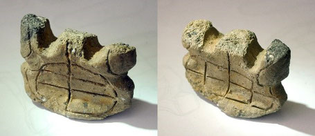
リサーチセンターでは、2018年から岐阜県中津川市苗木にある丸山神社内のフナ岩巨石群調査を始め、2021年までに中津川市・浅間山巨石群から関市のたんす岩巨石群までの約48kmに並ぶ北緯35度31分40秒の東西ラインの天文巨石ネットワーク(中津川市・恵那市・八百津町・七宗町・川辺町・美濃加茂市・関市)について、これまで報告してきた。
さらに私たちは、これらの巨石群がどのようにして構築されたのかを、幾何学geometry(図形や空間の性質について研究する数学の分野)の観点から探り、古代人の思考に迫ってみたい。特に紀元前300年頃のギリシャの数学・天文学者ユークリッドによってユークリッド原論『ストイケイア』にまとめられたユークリッド幾何学と、ドイツの数学者ダーヴィット・ヒルベルトの『幾何学基礎論』を参照してみた。
In 2018, we started investigating the Funaiwa megalithic group at Maruyama Shrine in Naegi, Nakatsugawa City, Gifu Prefecture. By 2021, an astronomical megalithic network on the east-west line of 35 degrees 31 minutes 40 seconds north latitude, for about 48 km from Nakatsugawa (Mt. Sengeyama Megaliths) to Seki City (Tansuiwa Megaliths), had been reported. Seven megalithic groups have been found in Nakatsugawa City, Ena City, Yaotsu Town, Hichiso Town, Kawabe Town, Minokamo City, and Seki City.
Here, we would like to explore how these megalithic groups were constructed from the perspective of geometry (the field of mathematics that studies the properties of shapes and spaces) and to approach the thinking of ancient people. In particular, we refer to Euclidean geometry compiled in "Euclid's Principles Stoikheîa" by Euclid, a Greek mathematician and astronomer around 300 BC, and German mathematician David Hilbert's "Geometry" .